smindel / silverstripe-gis
Geographic types for SilverStripe
Installs: 732
Dependents: 2
Suggesters: 0
Security: 0
Stars: 9
Watchers: 2
Forks: 6
Open Issues: 4
Type:silverstripe-vendormodule
pkg:composer/smindel/silverstripe-gis
Requires
- proj4php/proj4php: ^2.0
- silverstripe/framework: >=4 <4.3.1 || >=4.3.3
- silverstripe/vendor-plugin: ^1.0
Requires (Dev)
- phpunit/phpunit: ~5.7
Suggests
- ext-gd: to use GD library based tile rendering.
- ext-imagick: to use Imagick based tile rendering.
README
GIS developer toolkit for SilverStripe, turns SilverStripe into a GeoCMS and map service.
Features
- New field types: geo field types Geometry and Geography (Postgres only) for DataObjects
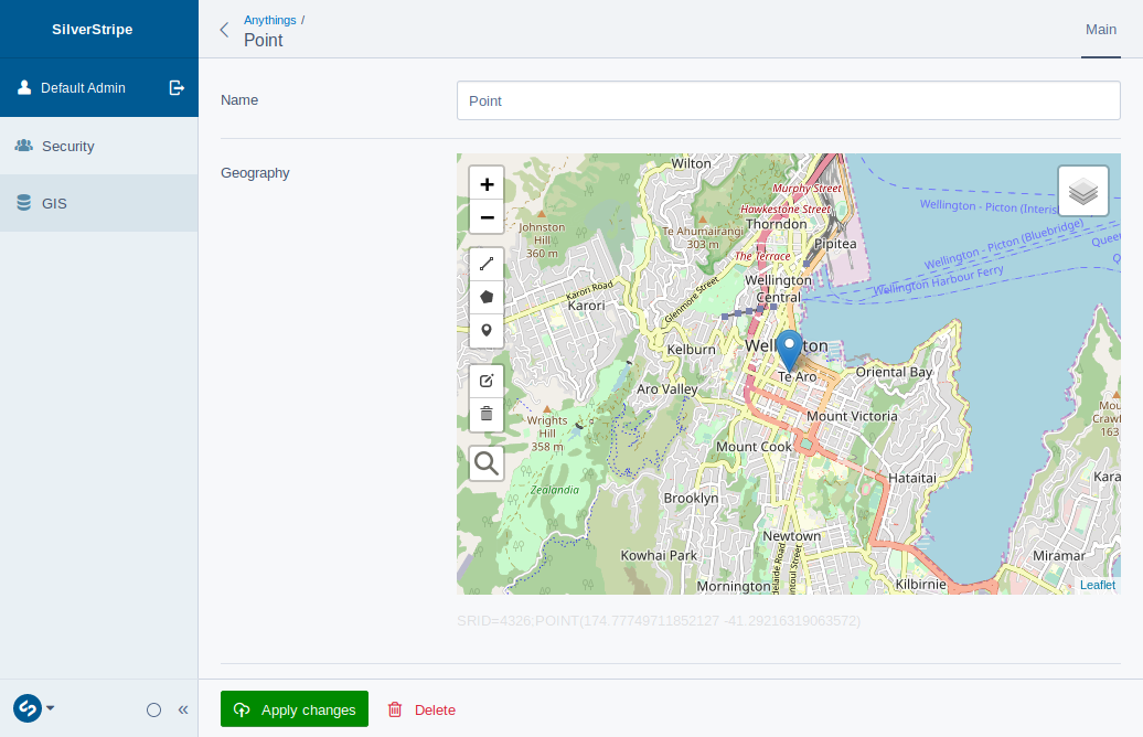
- New form fields: edit the new geo types using the MapField or add maps to GridFields in ModelAdmin
- Configurable projections: support for multiple projections through proj4
- Primitive and multipart geometries: Point, LineString, Polygon, MultiPoint, MultiLineString, MultiPolygon
- Developer tools: heaps of useful helpers, e.g. for re-projecting, distance measuring, EWKT
- MySQL, Postgres and Sqlite3: supports Postgres with PostGIS, MySQL 5.7+, partial support for MariaDB and Sqlite3 with SpatiaLite
- ORM integration: DataList filters, e.g. to find intersecting DataObjects or within distance
- GeoJSON imorter: import a GeoJSON source as DataObjects
- GeoJSON web service: GeoJSON API for DataObjects
- WFS: WFS for DataObjects (experimental)
- WMTS: render DataObjects to ZXY tiles e.g. for a leaflet frontend
- Rasters: (Postgres only) import GeoTIFFs, access values, generate stats and render map tiles
Requirements
- MySQL 5.7+ or Postgres with PostGIS extension or Sqlite3 with SpatiaLite
- SilverStripe framework 4
- GDAL for raster support
Installation
It's recommended to use composer to install the module
$ composer require smindel/silverstripe-gis
$ vendor/bin/sake dev/build flush=all
MySQL natively supports geometries since version 5.7.6 but not geographies or raster data.
When using Postgres you have to install PostGIS and composer require silverstripe/postgresql. On Ubuntu and Debian run the following commands:
$ sudo apt-get install postgis
$ sudo apt-get install postgresql-9.5-postgis-scripts
$ sudo apt-get install postgresql-9.5-postgis-2.2
$ sudo -u postgres psql SS_gis -c "create extension postgis;"
(replace 'SS_gis' with your db name)
Steps two and three may not be necessary, so you might want to try one and four first and if four fails, do two, three and four.
In order to install Sqlite3 you have to install SpatiaLite and composer require silverstripe/sqlite3. On Ubuntu and Debian run the following commands:
$ sudo apt install sqlite3 php-sqlite3 libsqlite3-mod-spatialite
$ sudo updatedb & locate mod_spatialite.so
> /usr/lib/x86_64-linux-gnu/mod_spatialite.so
update php.ini, set:
sqlite3.extension_dir = /usr/lib/x86_64-linux-gnu
Configuration
silverstripe-gis, like any other SilverStripe module, can be configured using YAML files, the Config class or private static properties of Configurables. Check out the following sections to see what can be configured.
Examples and how tos:
- Why would you bother? - And if you should, what should you bother about?
- DataObject Example - How to set up your own DataObjects
- GridFieldMap - How create a spatially aware admin interface
- MapField - How to edit geo types
- ORM Filters - How to retrieve DataObjects from the db using spatial filters
API:
- GIS - Spatial utility class with all sorts of useful helpers
- GeoJSONImporter - Import GeoJSON files into the db
- GridFieldMap - GridField component to browse DataObjects by map
- MapField - Form field to edit geo types
- GeoJsonService - Expose your DataObjects dynamically in GeoJSON format though an API
- WebMapTileService - Generate map tiles for Leaflet or Openlayers from your DataObjects
- WebFeatureService - Generate WFS for Leaflet or Openlayers from your DataObjects (experimental)
- Rasters - Import raster files, access values and stats, render WMTS tiles
Note
The module is incompatible with the framework versions 4.3.1 and 4.3.2, which disallowed parameterised field assignments. The issue has been fixed, so that all versions of the framework before 4.3.1 and after 4.3.2 are working.

