dantsu / french-cadastral-map-static-api
PHP library to easily get static image from French Cadastral Government map with markers and lines.
Fund package maintenance!
DantSu
Installs: 16
Dependents: 0
Suggesters: 0
Security: 0
Stars: 6
Watchers: 3
Forks: 1
Open Issues: 0
pkg:composer/dantsu/french-cadastral-map-static-api
Requires
- php: >=7.0
- dantsu/php-image-editor: ^1.4
- dantsu/php-osm-static-api: ^0.6
README
PHP French Cadastral Map Static API
PHP library to easily get static image from French Cadastral Government map with markers, lines, polygons and circles.
Map source : cadastre.gouv.fr
API PHP de Carte Statique du Cadastre Français
Librairie PHP permettant d'extraire facilement des images de la carte du cadastre Français avec des markers, des lignes, polygones and cercles.
Source de la carte : cadastre.gouv.fr
✨ Supporting
⭐ Star this repository to support this project. You will contribute to increase the visibility of this library 🙂
Installation
Install this library easily with composer :
composer require dantsu/french-cadastral-map-static-api
How to use
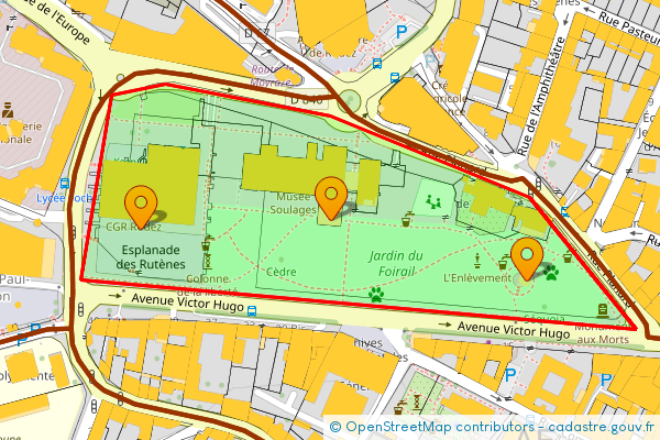
Generate French Cadastral map static image with marker and line :
use \DantSu\OpenStreetMapStaticAPI\OpenStreetMap;
use \DantSu\FrenchCadastralMapStaticAPI\FrenchCadastralTileLayer;
use \DantSu\OpenStreetMapStaticAPI\LatLng;
use \DantSu\OpenStreetMapStaticAPI\Polygon;
use \DantSu\OpenStreetMapStaticAPI\Markers;

\header('Content-type: image/png');
(new OpenStreetMap(new LatLng(44.351933, 2.568113), 17, 600, 400))
    ->addLayer(
        new FrenchCadastralTileLayer(
            12202,
            [
                FrenchCadastralTileLayer::LAYER_AMORCES_CAD,
                FrenchCadastralTileLayer::LAYER_CADASTRAL_PARCEL,
                FrenchCadastralTileLayer::LAYER_SUBFISCAL,
                // CadastralTileLayer::LAYER_CLOTURE,
                FrenchCadastralTileLayer::LAYER_DETAIL_TOPO,
                FrenchCadastralTileLayer::LAYER_HYDRO,
                FrenchCadastralTileLayer::LAYER_BUILDING,
                FrenchCadastralTileLayer::LAYER_BORNE_REPERE,
                // CadastralTileLayer::LAYER_VOIE_COMMUNICATION,
                // CadastralTileLayer::LAYER_LIEUDIT
            ]
        )
    )
    ->addMarkers(
        (new Markers(__DIR__ . '/resources/marker.png'))
            ->setAnchor(Markers::ANCHOR_CENTER, Markers::ANCHOR_BOTTOM)
            ->addMarker(new LatLng(44.351933, 2.568113))
            ->addMarker(new LatLng(44.351510, 2.570020))
            ->addMarker(new LatLng(44.351873, 2.566250))
    )
    ->addDraw(
        (new Polygon('FF0000', 2, '00FF00CC'))
            ->addPoint(new LatLng(44.351172, 2.571092))
            ->addPoint(new LatLng(44.352097, 2.570045))
            ->addPoint(new LatLng(44.352665, 2.568107))
            ->addPoint(new LatLng(44.352887, 2.566503))
            ->addPoint(new LatLng(44.352806, 2.565972))
            ->addPoint(new LatLng(44.351517, 2.565672))
    )
    ->getImage()
    ->displayPNG();
Documentation
| Class | Description |
|---|---|
| FrenchCadastralTileLayer | DantSu\FrenchCadastralMapStaticAPI\FrenchCadastralTileLayer define french cadastral tile server and related configuration |
For more documentation, see DantSu/php-osm-static-api
Contributing
Please fork this repository and contribute back using pull requests.
Any contributions, large or small, major features, bug fixes, are welcomed and appreciated but will be thoroughly reviewed.

